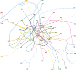
File:Paris Metro map.gif

預覽大小:653 × 600 像素。 其他解析度:261 × 240 像素 | 523 × 480 像素 | 836 × 768 像素 | 1,115 × 1,024 像素 | 1,927 × 1,770 像素。
原始檔案 (1,927 × 1,770 像素,檔案大小:214 KB,MIME 類型:image/gif)
檔案歷史
點選日期/時間以檢視該時間的檔案版本。
| 日期/時間 | 縮圖 | 尺寸 | 用戶 | 備註 | |
|---|---|---|---|---|---|
| 目前 | 2006年5月2日 (二) 04:12 |  | 1,927 × 1,770(214 KB) | Gonioul | |
| 2005年12月14日 (三) 14:12 |  | 1,899 × 1,769(175 KB) | Poulpy | == Summary == '''Author''': en:Metropolitan '''Origin''': en:Image:Paris Metro map.gif '''Description''': Paris metro network pictured at a geographically accurate scale. Released by the author into the public domain. |
檔案用途
沒有使用此檔案的頁面。
全域檔案使用狀況
以下其他 wiki 使用了這個檔案:
- ca.wikipedia.org 的使用狀況
- cv.wikipedia.org 的使用狀況
- en.wikipedia.org 的使用狀況
- eo.wikipedia.org 的使用狀況
- es.wikipedia.org 的使用狀況
- ja.wikipedia.org 的使用狀況
- lb.wikipedia.org 的使用狀況
- sk.wikipedia.org 的使用狀況


