File:Topographic map of the districts of Socotra (en).svg

此 SVG 檔案的 PNG 預覽的大小:800 × 229 像素。 其他解析度:320 × 92 像素 | 640 × 183 像素 | 1,024 × 293 像素 | 1,280 × 367 像素 | 2,560 × 733 像素 | 1,309 × 375 像素。
原始檔案 (SVG 檔案,表面大小:1,309 × 375 像素,檔案大小:412 KB)
.svg?uselang=zh-hk)
.svg?uselang=zh-hk)
.svg?action=history&uselang=zh-hk)
.svg)
摘要
| 描述 |
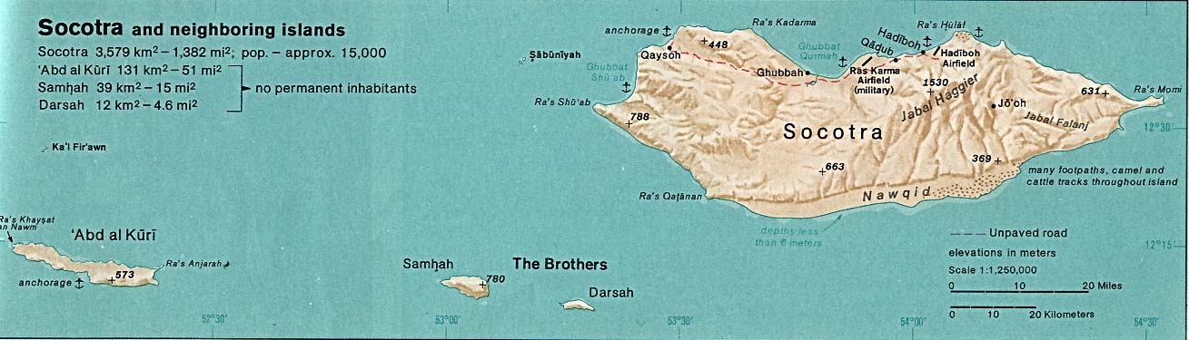
English: Topographic map of the districts of Socotra.
Deutsch: Topographische Karte der Distrikte von Sokotra.
Français : Carte topographique des départements de Socotra.
Македонски: Топографска карта на Сокотра.
Suomi: Sokotran topografinen kartta.
Русский: Топографическая карта Сокотры |
| 日期 | see file history |
| 來源 |
Self-made in Inkscape. |
| 作者 | Oona Räisänen (Mysid) |
| 其他版本 |
Derivative works of this file: |
.svg)
.svg)
|
This SVG file contains embedded text that can be translated into your language, using any capable SVG editor, text editor or the SVG Translate tool. For more information see: About translating SVG files. |
.svg)
授權條款
我,本作品的著作權持有者,決定用以下授權條款發佈本作品:

|
已授權您依據自由軟體基金會發行的無固定段落、封面文字和封底文字GNU自由文件授權條款1.2版或任意後續版本,對本檔進行複製、傳播和/或修改。該協議的副本列在GNU自由文件授權條款中。 |
您可以選擇您需要的授權條款。
檔案歷史
點選日期/時間以檢視該時間的檔案版本。
| 日期/時間 | 縮圖 | 尺寸 | 用戶 | 備註 | |
|---|---|---|---|---|---|
| 目前 | 2014年8月28日 (四) 20:31 | 1,309 × 375(412 KB) | Chumwa | ||
| 2014年8月27日 (三) 20:27 | 1,309 × 375(412 KB) | Chumwa | |||
| 2014年8月27日 (三) 20:07 | 1,309 × 375(413 KB) | Chumwa | == {{int:filedesc}} == {{Information |Description= {{en|Topographic map of the districts of Socotra.}} {{de|Topographische Karte der Distrikte von Sokotra.}} {{fr|Carte topographique des départements de [[:fr:Socotra|So... |
檔案用途
下列頁面有用到此檔案:
全域檔案使用狀況
以下其他 wiki 使用了這個檔案:
- ar.wikipedia.org 的使用狀況
- arz.wikipedia.org 的使用狀況
- bg.wikipedia.org 的使用狀況
- bn.wikipedia.org 的使用狀況
- ckb.wikipedia.org 的使用狀況
- de.wikipedia.org 的使用狀況
- en.wikipedia.org 的使用狀況
- es.wikipedia.org 的使用狀況
- fa.wikipedia.org 的使用狀況
- fr.wikipedia.org 的使用狀況
- ja.wikipedia.org 的使用狀況
- kk.wikipedia.org 的使用狀況
- nl.wikipedia.org 的使用狀況
- nn.wikipedia.org 的使用狀況
- ru.wikipedia.org 的使用狀況
- si.wikipedia.org 的使用狀況
- uk.wikipedia.org 的使用狀況
- ur.wikipedia.org 的使用狀況
- vi.wikipedia.org 的使用狀況
- www.wikidata.org 的使用狀況
.svg)